Monday, January 15, 2007

January 2007

Saturday, January 27, 2007

Jan 27th with Mike Brown

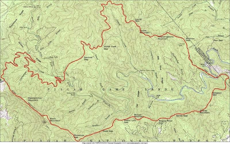
276->475->5003->CFR->Kissee Creek->140A->Farlow Gap->Daniel Ridge->475->276

33 miles 6589′ climbing

Click on the map or topo for a larger version.

Mike Brown and I went on a fun ride yesterday. We had every intention to pull out all the stops and ride a 45+ mile loop but alas, it did not work out that way. Between me going through the weirdest bonk in a while and Mike having mechanical issues, our pace was too slow to add in the extra 12-15 grueling miles AND make it home by the time we told our ladies we would.

We started at the Black Mountain trailhead and jumped onto the pavement to the Fish Hatchery. The air was cold but not freezing and by the time we took the turn onto 475 I had broken a sweat. We decided there to ride our loop clockwise so next was the climb up to Gloucester Gap. We made quick work of that climb and we took our first rest at 5003. I was working hard to keep Mike’s wheel on the climb up 475 so I let him l lead out on 5003. Again, we were working hard but the views were so incredible I slowed and let Mike climb away a couple times, just so I could enjoy the sights. One view in particular sticks out in my mind, there was no way to capture the scene with my camera, the panorama went 270 degrees around with Looking Glass Rock taking up the center of the view. Outstanding! We continued past the intersection of 140A and decended to Couthouse Falls Road. I took the lead for the first ttime of the day and HAULED ASS down to CFR. I nearly ran headlong into the mounds at the bottom but was able to bring my bike to a stop right as my front wheel broke through the ice of the puddle before the first mound. We climbed CFR and I realized my legs were starting to feel weak. Next was the turn onto Kissee Creek Road. Kissee is fun, the climb isn’t too intense and we found a very very cool spot. We found what has to be the largest boulder in the forest. This thing didn’t come out of the earth where it sits, it fell from far above. The thing is, it must be 50 feet tall. There are two nice little camps there, too. Nice, very nice, I’ll need to keep that place in mind for the next time Erinna and I go bike-camping.

Here’s Mike at the base of the really, really big rock:

We spent a little while there before continuing up Kissee. Next was the intersection at the other end of 140A where we hung a left and went on up to Farlow Gap. Once we were on 140A my legs were not cooperating in the least. My head was i n the game, my legs didn’t feel like they were ready to cramp, I just felt like I had ZERO power output. I would get on the bike and pedal pedal pedal but as soon as the trail got tech, I would get bounced off line and couldn’t recover. I ended up walking… most of 140A up to Farlow.

If you’ve never been on Farlow Gap trail then there is no real use in trying to describe the conditions. There are many rocky, rooty, and super steep trails in Pisgah but Farlow takes the cake. It’s the rockiest, rootiest, steepest trail (that actually has a trail sign and is approved by the USFS) in all of Pisgah. Mike was riding the perfect bike for the conditions, a 6inch travel front and rear suspension rig and he used everything his machine had to offer. Mike’s downhilling skills have improved expodentially in the last year or so. Mike cleaned some of the hardest moves on Farlow and I was lucky enough to witness them. Mike was on fire! He cleaned the first rock garden, the pseudo-skateboard drop, the steps, the steeps, the switchbacks, just about everything! Farlow has a good little climb in the middle and that’s when I realized I didn’t want to try the second half of our route. I was hungry, tired, and without power output.

Here’s Mike crossing one of the creeks after the super steeps on Farlow:

At about the same time we were dealing with Mike’s front brake, it seemed to have too much hydrolic fluid in it and was pumping up and causing the wheel to hardly roll. We got it working again before Daniel Ridge and continued our high speed descent. Mike pulled away in the tech, 12 inch wide benchcut, death to the right section and was waiting for me at the bridge ruins with a look like he had just seen a ghost. He told me he forgot exactly where he was, boosted off a root-pile, and had to force his bike through the rocks and turns that were ahead. Sweet move Mike! Next was the bottom of Daniel, through the gravel, across the bridge that was destroyed by the hurricanes of 04, and back to 475. We got out to 276 and kept a very heavy pace back to the car, well, it was heavy for me as I spun spun spun my SS while chasing Mike in his big-ring. We made it back to the Jeep in just over 5 hours. Not a super fast pace, but not too slow either.

Posted by Eric Wever / Pisgah Productions at 22:25:37 | Permalink | Comments (3)

Sunday, January 21, 2007

Solo Trace Ridge Ride

I just got in from a quick lap around the classic Trace Ridge loop. The plan to ride was finalized probably 10 minutes before I had to take Erinna to work and, since she couldn’t come along, it was the first solo ride for me in a long time. The weather was menacing, low 30’s and threats of rain, but I went ahead anyway. When I got to the parkway (the way I go to Trace) it was closed. I had to backtrack and drive up the gravel road through Bent Creek. I parked at Spencer Gap Trail and was on my bike within 5 minutes of getting there. The initial climb felt great, I made it to the super steep climb through the field rather quickly. I took it easy up through the rooty section then got on and hammered hammered hammered all the way to Trace Ridge. I didn’t take a break there, I just continued climbing to the top. I spun out and had to dismount once during that climb but otherwise did well. Once I finished that climb I again put the hammer down and spun the one gear I’ve got as fast as I could. The steep stuff was next and when I dropped into the little intersection/field place it felt as fast as ever before. My chest was on the saddle and I was right on the edge of control… Time to bring it back a notch… I cruised into the second climb, crested, and started to descend again. Rather than regaining breakneck speeds I decided it would be best to stop and take a photo…

Mount Pisgah from Trace Ridge:

Once I got rolling again I kept my speed in check. My hands were starting to hurt anyway. I had a lot of fun, overshot the big lefty turn like usual, and even hopped a few of the waterbars into the parking lot. Aaaahhhhh Trace Ridge…

Super fast. Super fun.

The rain was coming down as soon as I got into the parking lot so I decided I had had enough, time to ride the road on up to the Jeep. That is usually not very eventful but today… My rear tire went flat as I was passing the first gate. Crap. well, I only had a couple hundred yards left in the loop, so I just walked it on out. There’s something about walking up a road in the middle of the forest in not-freezing rain with a non-operational bike that made me just laugh. Thank God I didn’t have far to go. The humor would have lasted only so long.

Oh, by the way, WINTER HAS FINALLY ARRIVED!

Posted by Eric Wever / Pisgah Productions at 20:05:30 | Permalink | Comments (2)

Big Ride bail-out

Erinna and I met up with a larger than expected crew last Saturday for what was supposed to be a 50+ mile ride. We started at Black Mountain trailhead in sub 20 degree temps. Erinna seemed to be doing well, keeping the pace up hiher than I could respond to. Jonathon and I took up the end of the line for the initial climb of the day. However, when we regouped at Thrift Cove Erinna was having a hard-time, her feet were so cold they hurt. She doesn’t have appropriate cold weather shoes, her pink Italian leather Sidi slippers don’t allow even a second pair of socks. We convinced her to continue climbing, that if we kept moving she would warm-up. Well, when we got to the top of the climb she wasn’t doing any better, actually she was pretty miserable. Mountain biking is supposed to be fun, not miserable, so we decided to head on back to the car. Actually, the decision was made during the first descent when we came around a corner to the North face and an unconceivably cold blast of wind hit us. She was done and I wasn’t going to continue without her so we said goodbye to the guys and headed back to the Jeep.

In total we did 1.5 hours of riding, not 8, but the cold took it out of us… When we got home we felt like we had been on the bikes for days.

I managed to get a couple photos along the way. Here’s Jonathan and Dennis at a new sinkhole on Black Mountain:

and Jonathan at one of the steeps before Pressley Gap.:

Thanks for coming out guys! Next time we’ll be better prepared…

Posted by Eric Wever / Pisgah Productions at 19:44:29 | Permalink | No Comments »

Saturday, January 6, 2007

I just got in from yet another excellent ride in the Pisgah National Forest.

I rode with Dennis K., Bill Fehr, Teamdicky, Josh the Wonderboy, Jessie ‘The Dude’, and C’lotte Jonathan.

We met up at a little before 8 AM and were on the trail by 8:30 from the Turkey Pen parking lot. Our route for the day: Singletrack/not 66 jumps-> South Mills River->Mullinax->Squirrel Gap->South Mills River->Buckhorn Gap->Black Mountain->Turkey Pen Gap all the way back to the parking lot.

click on the map and topo for larger copies of each.

19 miles / 5030′ climbing

I have to say first and foremost, even though the classic Laurel Mtn./Pilot Rock ride I did a couple days ago had simular milage and elevation change, Squirrel Gap/Turkey Pen is a much, much more intense and technical ride. Today’s ride took just under 5 hours…

I hope to get a good ride description in later but I need to get a shower and eat some food. For now, a few photos:

We got out early and it was a beautiful morning. Here’s Josh off the bike climbing through the morning mist:

Jessie said ‘I had no idea Squirrel Gap was this much fun.’ while resting at Cantrell Creek

The man, the legend, Mr. Dennis Kuntz decided today would be a great day to ride in his backyard. This guy actually lives on the gravel road leading to the trails…. Lucky!

So, you think i should… reducemystemlengthandincreasemytoptubelengthordoyouthinkitwould

bebettertoshortenmytoptubeandincreasemystemlengthordoyouthinkishouldgeta73mmbottom

bracketsoicangetshorterseatstaysorshouldijustforgetaboutitandtrytooperatemywaterfilterwhile

myeyesarecloseduntilihavepracticedfillingonegallonjugsenoughthaticandoitinundertwominutes?

Here’s Jessie at the bridge at Wolf Ford:

Bill pushing up Black Mountain:

and climbing (on the bike) still on Black Mountain:

Josh at the Black Mountain/Turkey Pen intersection:

and at the other end of Turkey Pen Gap trail:

and finally, a vid of Bill… I wish the camera was able to show how steep the trail really is here:

Posted by Eric Wever / Pisgah Productions at 20:20:44 | Permalink | Comments (3)

Thursday, December 14, 2006

December 2006

Sunday, December 31, 2006

WIIIIIIIIIIIIIIILSON…….WIIIIIIIIIIIIIIILSON

mtbr thread here

Yesterday Erinna and I joined a H U G E group for the mountaingoatepics pre-new years ride up at Wilson’s Creek. Mike B. and Jonathan rounded out our carload of people and bikes for the road-trip. We met up with the rest of the riders below the dirt-mounds off 181 and then shuttled up a number of miles of pavement to the start of the ride. After some research I’ve come up with the list of players: From South Cackalacky: Jonathan (extrmtao). From the Charlotte area: Josh the Wonderboy, Rich (Teamdicky), Dave (SurlyDave), Sam (Spoke), Rob C., Jerry (Enoch), Craig (Mr. Roach), Jack C., and Chris P. From the Asheville area: Jeremy (mountaingoatepics), Scott (Mr. Zippy), Mike Brown, Erinna, and myself. Rich and Josh had gotten there early enough to get a head start and use the least amount of gas possible, they rode on up rather than shuttling. Here’s Jonathan before the group got started:

We had a good little warm-up on gravel road and I got a flat! How could I have gotten a flat on gravel road???? My rimstrip had shifted rendering my tube useless. Yes, this was a sign of things to come:

Our first trail of the day was No-Name. That trail was insane. It was more like bike sking than anything else. No warning came from those in the know, We just dropped off the face of the mountain. I was riding behind Rich, trying to keep my back wheel rolling rather than skidding, and I was giggling out loud. Awesome descent. Unsustainable, but awesome.

Here’s a shot from during the first big downhill. Go Sam!

We crossed a fire-road and continued on double track for a while that climbed and climbed and climbed. There were a number of creek crossings to deal with also. Erinna knew exactly where we were at this point and let me know to not worry about trying to keep our feet dry, scenes like this were ahead:

We eventually crossed the highway and dropped the Greentown Plunge. It had been a long time since I had beed there but did remember that there are huge jumps, huge berms, and huge potential for trouble all the way down to the creek. During one tech manuver over a slick rock -outcropping I went down pretty hard. My front wheel didn’t go where I wanted it to and was suddenly going in the wrong direction all together. My frame took the brunt of the fall and is now sporting a dent in the top-tube. Ouch!

Here’s a shot of me haulin’ downhill taken by Jonathan:

While crossing the creek down at the bottom of Greentown Dave decided to take a swim. Actually, the water was running so swift, the creek decided for him Here he is in suprisingly good spirits after going under:

Next was a long slow climb on double track up to our next trail, Raiders Camp.

Here’s Erinna and Jeremy climbing climbing climbing:

Here’s Erinna crossing a creek/waterfall along the way It was slick!:

Here’s another angle of that place. One wrong step and you could be sliding to your death!

Here’s a part of the group, at rest, waiting for the stragglers at the top of the climb:

and a photo of all the 29ers that we had out there. Incredible!

Lenz, Zion, WW, Salsa, GF, Niner, WW, Soma, Surly

Once we regouped we headed into Raider’s. Man that was a blast! Rocky, technical riding to say the least. The descent went on and on and my hands were already starting to feel fatigued. I would lead out with the first three or four on the downhills but had to move over to let folks by and to shake out my hands. Half way down Raider’s we made a turn to go to a waterfall overlook. I took the old rutted out line (that was super steep) and smashed my singleator on a stump or rock or something that stopped me dead in my tracks. I didn’t notice anything wrong at the time and continued out to the overlook… which was simply amazing:

It’s hard to get an idea of how huge this waterfall is or how high we were above it. See the dark blob at the top of the photo to the right of the fall? That’s a photographer type person. So, little black blob= 6′. How’s that for a scale?

We after a lot of ooooh’s and aaaaaah’s we backtracked to Raider’s and continued the downhill. Along the way I realized that the hit had damaged my singleator. Mike B had a mechanical issue also so we stuck together until we regrouped with everyone else. The rest of raiders was not nearly as steep as the top but was still fun fun fun. Our next scheduled stop was the Wilson’s Creek Trading Post but I had one unscheduled dismount along the way. I was trying a little tech move/creek crossing thing and again my front wheel slipped out. I fell off into the abyss with every limb and digit at full-extention. I landed on my feet and was relatively unharmed. My elbow hurt from the over-extention and my forearm took a big hit, but after a few moments I was O.k.

We stopped at the country store and everyone drank soda and ate little-pies. I had my eyes on the Vienna Sausages but resisted. Don’t laugh! I came sooo close to getting a can of those little squishy meatsticks.

Rich and Josh decided they had had enough at this point and went back to the cars. The rest of the group had a 3 mile climb ahead.

The group was starting to get rather splintered at this point and we had a long break at the top of the gravel road. A group of riders met up with us coming up from the otherside. It was the Hick Hucksters, a group of local-yokels on big bikes and wearing body armor. Sinkhole trail was next and they were ready for anything it could throw at them. Here they are just before the last big descent of the day:

Near the bottom of that incredible descent is a… umm… Sinkhole. Actually, it’s a remnant of an attempt to mine Uranium in the area and is a 6 foot wide, 25 foot deep, hole right in the middle of the trail. On the way down I somehow broke my chain! Jeremy hung back while I tried to get it fixed. I did fix the chain (once while it wasn’t even installed on the bike (doh!) but I had a more serious problem, the hit my singleator took had made it more or less useless. The spring wasn’t holding and so my chain tensioner… couldn’t tension my chain. Crap. Well, I put my chain in my camelbak and took off down the final bit of descending of the day. After the sinkhole the trail was seriously steep. Erinna, Jeremy, and I were the last ones in the group and we were starting to run out of light. Jeremy held back as I alternately pushed my bike like a scooter, or a kickbike, or just rode it down the hill. While crossing one tech section I had my final crash of the day and ended up wrist deep in muck and with a black and blue lump on my thigh. Crap! Riding without a chain is hard. I never realized it before! The final final final bit of decending was worth mentioning. The trail became 12″ wide benchcut with very serious consiquences for mistakes. If you were to fall off that trail you wouldn’t stop tumbing for hundreds of feet down to the creek below. I glanced over the edge once and was quickly reminded that you WILL go where you’re looking, and to never look where you don’t want to go… The trail then popped out onto a grassy road and 100 yards of kick-biking later, we were back at the cars. Great ride. 30+ miles, 6 hours 45 minutes. My bike has never looked so rough after a ride. Dented toptube, Bent Derailler hanger, Chainless:

Thanks for coming out everybody! Thanks for leading Jeremy!

Posted by Eric Wever / Pisgah Productions at 18:10:47 | Permalink | Comments (3)

Thursday, December 28, 2006

Thursday Ride!

Erinna and I went met up with a bunch of folks this morning for a 2.5 hour ride starting at the Horse Stables. We got there moments before being officially late and were ready to go pretty quick. The start up Clawhammer wasn’t easy, especially since we’ve both been off our bikes. The group stopped at Maxwell and we took a quick breather readily. The next 3 miles up Clawhammer went by fairly fast. Erinna stopped to take off a layer while the group continued on and Jonathan and I took a moment to catch up and wait for Erinna to catch up. We made it to Buckhorn Gap more or less as a group.

Clay, Joe, Jody,Jonathan, Clealan, Scott (arriving from he other direction), Erinna, and Dennis

Just as we got there a guy came rolling up Buckhorn trail. He said hello and ‘Is this the group that started at the stables?’ Umm, yeah, it was the the guy from the mtbr forum that was going to try to meet us after starting in North Mills River! He started at 10 o’clock, we started at 10 o’clock, that was the only plan. He started miles and miles away from where we started. How cool is that? Here’s Jonathan and Scott right then:

We decided to head on up to the shelter from there. It was occupied so we continued on to the next gap. The climb past the shelter was tough. Again, I felt the lack of time on the bike lately. Anyway, Everyone was grouped together, there wasn’t anyone waiting ahead or anyone lagging behind, so I was fine. Here’s Jonathan and Jody:

I did try hard and did clean a couple of the steep ups, but the group was all about having fun, not racing. Here’s a shot of Joe heading up to the first desent of the day:

O.k, thats all for now except for a few more photos…

Quick Rest at one on the knobs:

Scott from Indy:

4 of 9 riders were on 29ers:

Get it Clay! Clay Faine setting up for some of the hard stuff on Bennett:

Posted by Eric Wever / Pisgah Productions at 23:14:46 | Permalink | Comments (2)

Saturday, December 23, 2006

Merry Solstice everbody!

Sorry for the non ride updates…

Here is our holiday guest and former resident, Maringo, and Sophie hangin’ on the porch.

There are good rides planned… more soon.

Oh, by the way, I need to say ‘thanks’ to Liberty Bikes for their no-hassle warentee of my delaminating Nevegal.

THANKS!

Posted by Eric Wever / Pisgah Productions at 23:07:47 | Permalink | No Comments »

Saturday, December 16, 2006

Bent Creek Group Ride

Wow! 15 riders! Behold the awesome powers of the mtbr NC forum!

Bill Fehr, EricVanDriver, Clint-Huck-Clint, TeamDicky, Drew, Gabe, Thad, Monster-Calf Bearded-Guy, M-U-M, Supercracker, litespeedchik, litspeedchikshusband, Wode, mountaingoatepics, and me!

20 miles and 3 hours at Bent Creek

Hard times-> Homestead->Deerfield->Pinetree->Explorer->Sleepy Gap->S Ridge->Chestnett Cove->Explorer->??? Rd->479->lower sidehill->sidehill->lower sidehill->boyd branch ->R.I.P little hickory->N. Boundary->Greens Lick->??? rd.->Sidehill->boyd branch->campground connector->connector to hard times.

While we were all out doing that ride Erinna was doing something much more torturous, running Laurel Mountain-> Pilot Rock with SophiePuppy.

I don’t have any photos of the ride or Erinna’s run. However, I did remember to bring the camera to the next thing we did, working the Warren Haynes X-Mas Jam.

Here’s a vidcap pic from the show:

and Erinna and I backstage, making sure all the equipment is working properly:

Posted by Eric Wever / Pisgah Productions at 23:38:57 | Permalink | No Comments »

Monday, December 11, 2006

Dec 10th Fish Hatchery Tour with Mike Brown

Starting at the Fish Hatchery->475B->Cove Creek->red blaze connector->5046->Daniel Ridge-> up! Farlow Gap->140A->5031 (Kissee Creek Rd)->140 (Courthouse Falls Rd)->5003->471 (Cathy’s Creek Rd)->471D->Butter Gap->Long Branch back to the Fish Hatchery.

26.2 miles, 7595 feet of climbing.

Mike Brown and I had an excellent ride yesterday. We started at the Fish Hatchery and 475B. The pace was pretty swift from the start and it took a little while for me to get warmed-up and to catch my breath. The turn to 225 came very quickly, much quicker than during the Swank, at least. Our goal for the day was to eventually climb Farlow so we could have taken 225 to the connector to Daniel but we decided against that and descended Cove Creek (Paint Shaker) back towards the Jeep. Down at the group camp we took the connector trail over to 5046. It’s not on the map and it doesn’t have a sign but it’s blazed red so I figure it’s an O.k. connector. Anyway, that was longer than I remembered and the first real singletrack ascent of the day. We popped out onto 5046 and took our first break of the day. It was sunny and warming quickly. I was overdressed in medium weight tights and 100wt. fleece. Roll the tights into knickers and push up the sleeves ’cause some serious climbing was next. Up Up Up, past this pretty waterfall:

and holy smokes we were at the intersection with Daniel! Up Up Up Daniel to the second killer singletrack descent of the day. The top of Daniel is pretty tech. Mike and I both were running the Nevegals F&R for the first time so we were really pushing hard throught the techs. Roots? Rocks? Off-Camber? Corderoy? Rockyrootyoffcambercorderoy? Yes, the Nevegal ate it all alive. We made our way to the bottom of Farlow and missed the connector to 225. We just wanted to scope it and figure-out if it’s blazed, signed, legal?… I’ll have to give my Forest Service guy a call. Anyway, up Farlow was next. No-one has ever suggested going up Farlow for any good reason to me ever. So why were we there? Dicky has planted some evil seeds in my mind…. that’s all. Farlow is about 4 miles long and is a freeriders dream trail (going down). The first two miles were filled with *killer* singletrack climbing, switchbacks galore, huge obsticles, and spectacular creek and waterfall crossings.

Here’s one of the waterfalls:

Landslide!!!

After about two miles of rolling singletrack we hit what we were calling ‘The Wall’. Not a metaphysiological barrier, we’re talkin about a MOUNTAIN. We hike-a-biked for a solid hour? after the last creek crossing.

Mike B hike-a-bike up Farlow:

but, as it goes when you just let time pass and you continue to move through space, Time and Space pass… and we made it to Farlow:

We had a few choices there and had planned on finalizing the route at that point based on how we were feeling and what time it was. We were feeling great and it was still early enough so we headed down 140A and took the right onto Kissee Creek Rd. Kissee was another place that the Nevegal just showed itself to be an awesome tire. I’m so happy to finally have some real knobs! We s e r i o u s l y hauled ass down Kissee to Courthouse Falls Rd. Down down down the gravel to the left at the mounds and up up up 5003. Mike was starting to show some signs of fatigue and I took the cue to slow it down a little, too. I’ve been back in that neck-o-the-woods a bit lately so I knew the landmarks and they rather quickly clicked on by. It took very little time to get to the 140A intersection but the next hill got me, my fatigue point was only 10 minutes behind Mike’s. We passed an elderly hiking couple right as we passed over the top of the last climb. The man said something to the effect of ‘It’s all down hill from here’. Well Yes Sir! We got a little mojo back and started really turning the pedals and just like that, we were at Glouscester Gap.

Butter was our final trail of the day. We ascended Cathy’s Creek, dropped down the backside, wondered if we had passed the turn, found the turn, and took a break. Next was the climb up the old gravel road to Butter Gap. We had sat for just long enough for a chill to come over us at the break but the climb to Butter was just hard enough that I was nice and warm at the top. Here’s Mike at the top of 471D:

The final descent of the day was before us. Butter is sooooooo much fun. Tech moves, smooth and fast sections, tech moves, creek crossings, and tech moves. The bottom is super fast and has a cool perpetual S turn feel. The final final bit of trail was Long Branch back to the Jeep. Long Branch is classic Pisgah. Steep rooty slopes, fast flast running next to a river, rocks, roots, mud, slime, climbing, descending…. everything you could ask for in a two mile stretch! We passed a guy on a vintage Ibis right at the end. Nearly 6 hours in the woods and we saw 3 people all day. That’s pretty cool.

Great ride. Maybe I’ll call this one the West Side Nasty.

Posted by Eric Wever / Pisgah Productions at 00:36:34 | Permalink | Comments (2)

Thursday, December 7, 2006

funfunfunfunfunfunfunfunfunfunfunfunfunfunfunfunfun

notes about todays ride, not an attempt at poetry, thank you.

Singletrack rather than double

Camping hunters going for a 3 day trip even though 18 degrees on fri

Crossed bridge

Mullinax seemed to take forever took breather at pea gap

Then felt g o o d.

Everyone rockin the tech moves

Close call with the edge

Knocked out each landmark

pea gap laurel trail sorba benchcut horse f’ed section laurel mountain

Tech tech tech tech to cantell.

Mentally taxing.

Fast too.

Cleaning just about everything. Again good tech day

Made our ride decision with 1 hour 5 min until sunset

Time to get wet.

Not steep but very tech

More creek crossings than I remembered?

But air temp was just fine.

Dead stop…. Big S turn tech move. Clap your hands say Yeah!

Mud hole ass cheek deep. Primordial soup.

Is this Cantrell creek or Cantrell creek trail?!?!

Bent front chainring. good thing I had my pliers…

Took longer than expected to get to the lodge ruins especially considering possible mechanical

Dreaded RIVER crossings next

First crossing was tough deep cold FAST. SLICK. A BIG F’KER

Longer than expected to next crossing, thinking of nothine else

Second crossing, longer but not as deep or slick.

Spin spin spin spin spin down s. mills river trail

Had to get off to get circulation back into the feet on the one steep climb

Descend past poundingmill, climb, descend, regroup at mullinax WODE DOWN! for the closing of the loop ceremony

Down to the bridge and Mike decides to climb back up the single track

Final big effort.

Back at the Jeep in 2.5 hours.

Posted by Eric Wever / Pisgah Productions at 00:27:50 | Permalink | Comments (2)