Tuesday, October 31, 2006
Fun, Fast, 75 minute, ride with Wode
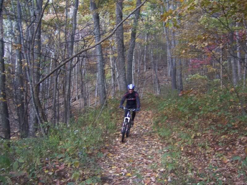
Wode and I did a quick little Pisgah ride yesterday. The DOUBLE DARE race was this past weekend and as the director I had zero chance to get out on the trails myself. Wode and I arrived on Monday morning at White Pines to finish the last of the tear down from the race, took care of that rather quickly, then headed up 477 to Bennett Gap trail.
It wasn’t an easy start but that was to be expected considering the lack of sleep I had gotten the nights before. Even the flat ride from the campground to the horse stables seeed to take forever. Well, once we hit the climb we both put the hammer down a bit. It took a while to warm up but once the blood was flowing I was feeling good. I started to push the single gear over and over and found myself standing up and moving prettty fast. Wode was right there until about the gated road. I looked back over my shoulder and he had disappeared. I continued on up the hill and waited at Bennett for him. Up the false climb and down Bennett. While going downhill the first time I nearly crashed due soley to the beauty of my surroundings. The leaves are in full color right now. There are still a couple green trees and sthere are even some with no leaves at all. The understory at one point was so fantasticly green that I had to come to a stop to take it all in. If you’ve ever ridden with me you know it usually takes some serious sh!t to make me stop on a downhill and the color out there yesterday was serious. I realized at one point that I wasn’t focusing on the task at hand (riding my bike down one of the more tech descents in Pisgah) and was just taking in the beauty of it all. We made it to Coontree and on back down to 477 rather quickly and wrapped up the ride in 1 hour 15 minutes. Super fun. Thanks Wode!
Wednesday, October 25, 2006
So THAT’S what bonking feels like…. It had been a while.
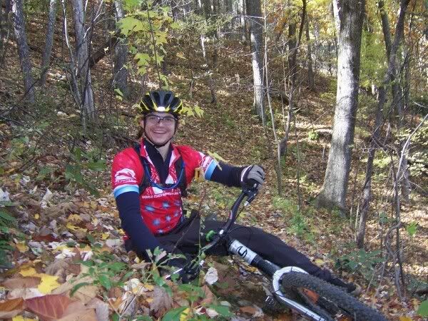
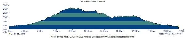
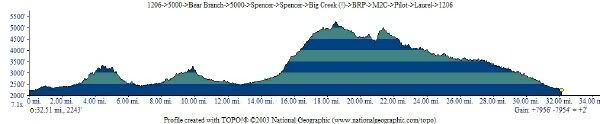
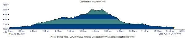
I went on another day of Long Slow Distance today. This time with Ian (Plume), Jonathan (extremetao), and Dave (David George). We started at NMRC, climbed 1206 and continued that way until S. Mills River Rd.->5018->Horse Cove Gap->Squirrel Gap->Laurel Creek->5015->1206->Pilot Rock…. and I had to bail-out. Bit of more than I could chew, so to speak. Dave bailed at the top of 5015 so it was three of us until the Hum-Vee section on Pilot where I bailed. The other two contiunued up Pilot to the BRP and on to Big Creek. If they’re lucky they’re finishing up about now, after I’ve been home for an hour and have warmed up with a hot shower and a bowl of spicy soup. Here’s the profile of my day. Oh, by the way, WAY TO GO PLUME AND TOMATO! Sorry that my legs, then mind, turned to mush.
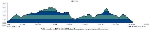
40.76 miles, 9345′ of climbing, 6 hours in the woods.
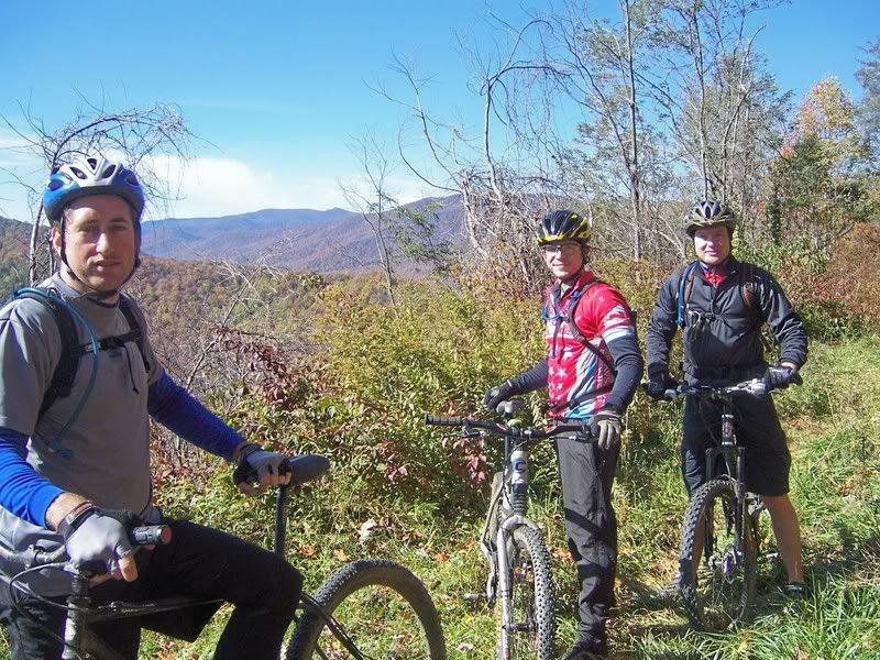
A few photos:
Jonathan says: Soon We’ll be WAY over there!
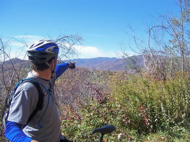
The whole crew (minus me, the photographer)
Jonathan says Wait… where are we?
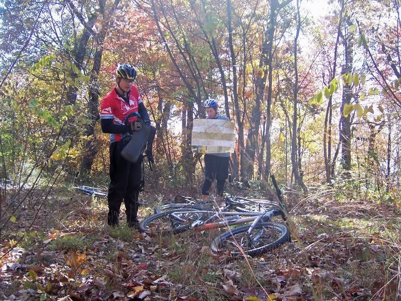
David had to bail before me but was strong and consistant all day
That’s one FAAAAAAST Tomato!
Ian!
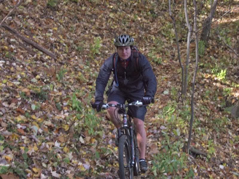
Tuesday, October 24, 2006
Backside of Farlow with Wode
Wode and I just got in from a good day full of Long Slow Distance. We did Backside of Farlow from the Fish Hatchery with an extra out-and-back to Courthouse Falls Road.
Here are some photos for now:
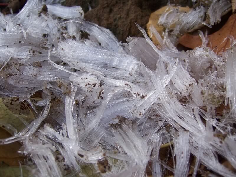
It was pretty cold when we started. Here’s a pic of a cool ice formation at the top of Pilot Mountain Road.
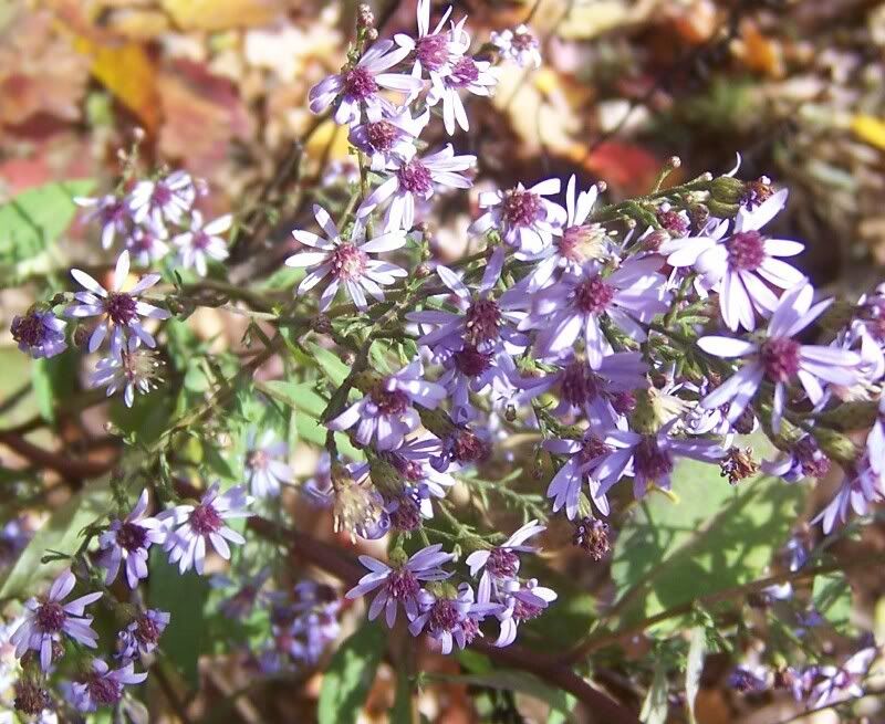
Funny enough, there were flowers right there as well.
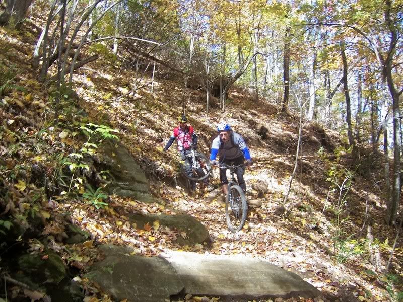
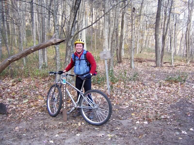
the riding was excellent. Here I am at Farlow Gap:
and Wode at Farlow:
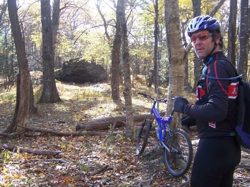
another shot of Wode, this time on 140A
and the last one for now. It turned into a beautiful fall day.
Saturday, October 14, 2006
The Extreme Tomato Ride!
I just got in from a borderline epic ride with a bunch of folks I usually don’t ride with on trails that I usually don’t ride in the direction that we rode them. Excellent! Change is great! The list of players: Mike Brown, Jeremy Arnold, Jared Weeks, and Jonathan, Jay, and David from Greenville, and myself. Jonathan (The Extreme Tomato) got everybody together for this, O.k., I’ll call it an epic ride, through the magic of the NC forum. Mike and I ride pretty often together, Jeremy and I havn’t ridden together in about a year, and the rest, it was my first ride with them. Mike and I were a good 15 minutes late and caught the guys right as they were leaving. Mike and I got ready very quickly and started very very quickly chasing after the rest. Once we caught up everyone started to make a plan. Up 5000 and over to Bent Creek? Noooo… Up Trace to Spencer? Noooo….. Spencer Spencer Laurel Pilot? Maybe…. Oooh! Oooooh! I know, let’s torture ourselves as best we can! Let’s get all our masochistic tendencies taken care of for the weekend and do 5000->Bear Branch->5000->Spencer->Spencer-> then go *cough* UP Big Creek to the parkway->Pisgah Inn->walk Mtn’s to Sea to->Pilot->Pilot connector->then Lauel Mountain all the way down to->1206 and back to the cars at 1206/5000? O.K! was the group concensus. My evil sadistic mind forgot all about the fact that I had to do it all, too. Oh well, I was up for it, even on the FULLY RIGID SINGLE-SPEED. Fine. 30+ miles? Fine. How hard could it be?
Oh.
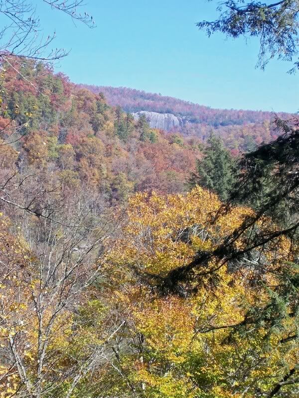
The ride started out chilly after the first frost hit Asheville the night before. Mike and I were ready quickly and hammered to catch everyone else at the intersection of 5000/Trace Ridge Rd. They complimented us on our speed, I looked like the tomato, and we headed up to do Bear Branch. Up the road, through the pine forest and the resulting soft trail and up up up further than expected, just like every time. We all made it to the trail head and bombed down Bear. We had two flats and a slight mechanical but after the regroup we finished Bear rather quickly. Next was 5000 to Spencer and everyone made acquaintances and after the one steep, it was a left on Spencer. I took lead because I was n’t really feeling warmed up yet and wanted to take care of that. We made it to the field climb quickly and my goal was achieved, I was warm, so I took off a layer and settled in for the long haul. I’ve mentioned before, Spencer Gap up is a ton of fun, rolling single-track all the way to Trace Ridge. We made our final route decision there (are we really going to CLIMB Big Creek?!?) and with everyone aboard, we headed down Spencer Branch. Spencer is awesome. Mike mentioned that it’s one of the few trails that is as steep as it is that has maintained itself rather well over the years. No maintenance, little traffic, remote feeling. The downhill is covered in nasty wheel eating rocks and eventually starts to run with the creek and crossing little tributaries that makes for tricky decendin, despite the lack of elevation loss. Cross the never ending road and continue on Spencer. I was surprised by the horsy mud-pits that preceded every waterbar and even more by the sheer clif down to what sounded like a waterfall (Death to the Left!!! I didn’t look to find out) that accompanied the bottom of Spencer heading to the reservoir. I usually take a left there and head to the short but annoying climb and the bobcat downhill so Spencer all the way was a nice change. We made our way around the reservoir and started up Big Creek to Little Pisgah Ridge next. This was a brand new experience for me and boy ‘o boy, it sure wasn’t easy. Big Creek trail is an old logging railbed, we actually found some light gauge rail today, and is 8 to 10 feet wide, covered in babyhead sized rocks, log corduroy, mud pits, and creek crossings for what seems like forever. When we got to any of the landmarks I recognized from going DOWN the trail, I would think, ‘Oh dear God… ‘The best part of Big Creek going up was the new stepping stones across the creek crossings. Big Creek has been a guaranteed wet feet ride since the hurricanes but someone has placed HUGE stepping stones. Mike tried to explain some sort of mechanical device that one can put in a backpack and then move 3 man rocks by oneself, but I was confused and was really thinking about the next part of the ride Big Creek up to Little Pisgah Ridge, and on to the Blue Ridge Parkway. That section of trail changes 2000 feet in 2 miles. It’s just climbing up a wall of merciless Pisgah single-track. Hey Suess! Jeremy and Mike were always within earshot and they were trying hard with their fancy geared machines. I saw Jared a few times just a few yards behind me but everytime I would get on and spin that single gear I wouldn’t see him again for 5 minutes of so. Mike, Jeremy and I arrived at the top, with Jared only moments behind, and we all sat in the sun and remarked on the difference between the leaf color there, (PEAK LEAF SEASON ALERT!!! Go up the parkway tomorrow! It’s beautiful!) compared to at the bottom where the peak is a week or two away still. We sat in the sun and sure enough, everyone else was there quicker than I could have hoped. We walked out to the parkway and pacelined up the hill, through the tunnel, and to the Pisgah Inn. The group split in two as we headed towards the Inn but again, they were they very quickly. We then walked up the mountains to sea trail and on to Pilot Rock.
No photos… more words later.
BRP->Trace->Spencer->Never Ending Road->Fletcher->Res. Rd->5000 w/ Wode
I’ll write about this ride soon. For now, check out this quick video of me on the steep downhill section of Spencer:
Wednesday, October 11, 2006
I love Mountain Biking!
Monday, October 2, 2006
The Fall Gathering ~ 2006
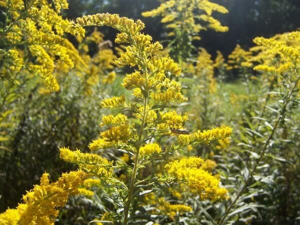
This past weekend was the 2nd annual Fall Gathering out in Pisgah. What’s the Fall Gathering? Well, just a bunch of folks brought together by Zach Broussard and the powers of the NC forum on mtbr.com. The intentions of such a gathering of like minds are simple: Ride Bikes, Drink Beer, Repeat. I arrived at White Pines around 1 p.m. Saturday to a bunch of tents and a spattering of pink flamingos but hardly any people. They were all out riding on that beautiful early fall day. The sky was bright blue, the leaves were still green, the flowers were everywhere:
and temps were in the low to mid 60’s. I decided to head out on a solo ride, my first in quite some time in Pisgah. I occasionally hit Bent Creek by myself but know it’s best to ride the rough stuff with some company. I did a quick sub 90 minute loop since I knew Dicky and Josh were going to want to ride once they arrived later in the day. 477->Bennett Gap->477. The climb up 477 went by fairly quickly as I knocked the cobwebs out of my legs. It had been a long time since I did that climb so I was suprised to recognize the landmarks. Powerlines, Perry Cove, the gated road, the top! WooHoo! Now, I know the map says that Bennett is seasonal so don’t go breaking them out to say ‘Eric! You poached!’ because the sign on the ground says Bennett is open. The forest service can change the signs on the ground but not a misprint on 10 million maps. I go by what’s on the ground. Anyway, up the false climb and down Bennett. I took it easy in the rough since I was alone but kept the pace up and made it back down to camp pretty quickly. Great little ride:

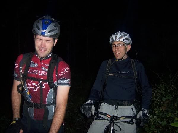
Once back in camp there were people milling around, the fire was getting started, and oh my god, the beer drinking had begun. I popped open a refreshing Sierra Nevada, cooked a can of soup, and waited for the arrival of Teamdicky and Josh the Wonderboy. By the time they did arrive I noticed the Sierra bottle and it’s friend the PBR bottle sitting at my feet and the PBR’s twin brother in my hand. Dicky came into camp wide eyed and talking fast which signified ‘get dressed or were going to leave you’ so I quickly got the cycling gear back on and after a quick discussion we were rolling up 477 to do the exact same loop that I had done a few hours earlier, again. Josh immediately took off like he was racing, Rich hung back with me, talking at me like his heartrate was hovering around 90BPM, and I was pale, full of cheap beer, and pushing as hard as I could. Holy f’ing crap guys… what did Race Face implant in your legs up at the TR? Anyway, I made a puking noise at Rich which he knew meant, ‘wait for me at the top’ and just like that… he was gone. I eventually made it to Bennett for the second time in the day and realized one of the reasons I was feeling so sluggish, my front tire was nearly flat. After a 20 minute tire change it was up the false climb again , through the field of pretty flowers:
and once again, down the riproarin’ descent known as Bennett. I exercised a bit less caution this time and hammered as fast as I could. I skipped the squeezebox but went for the thread the needle. I arm checked the huck rock but made it through unscathed. Up the hike-a-bike and down the final descent should have been easy but Josh had a flat that took a while to fix and we were suddenly looking at getting out of the woods late into dusk. We had lights but decided it would be more exciting, and manly, to try to just feel our way down the mountain. I led the group and could see well, nearly just fine. I could make out the large rocks, drops, and rootballs anyway. As they arrived Rich was calling me cat-man because I hardly slowed down and they couldn’t see squat. If you just open your eyes guys, you could see like a cat too!
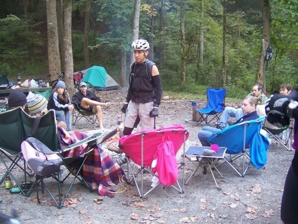
Once back in camp we changed, fed ourselves, and let the festivities rule the evening. As Tara pointed out the ‘roudy’ group was pretty tame compared to last year but since I decided early to limit my consumption of adult beverages I noticed a few folks getting a little silly, the fire getting a little huge (thanks tomato!), and the number of bottles ever increasing. I missed the now legendary lapdance given the Jody but the description left a lasting (scaring?) image in my brain. There was even a little homo-erotic behavior going on so it was easy to see the average BAC was probably hovering around twice the legal limit. Rich Josh and I closed the place down sometime a few hours before dawn and they left a few nice images on Brad’s camera that will remind him to never, ever, leave his camera unattended again.
I was up feeling bright eyed and bushy tailed the next moring right at first light. After a little breakfast, a little coffee, and a little water Josh and Rich were up and ready to go. We thought we were the super-motivated ones and a little superior to the rest. Ha! We can party til dawn and still beat you to the trails in the morning you slackers!
Rich hadn’t done Avery Creek trail in a number of years so that’s where we went. Clawhammer->Black Mountain-> Avery Creek.
It was a chilly start but Clawhammer took care of that issue rather quickly. I was feeling pretty good but those two again, just rode away from me like I was standing still. Rich explained later that after doing the TR, Pisgah just doesn’t seem all that steep. Gah! I pushed as hard as I could so I didn’t arrive an embarrassing huge number of minutes behind them but did stop once to take another photo of a specimin of the abundance of wildflowers here:
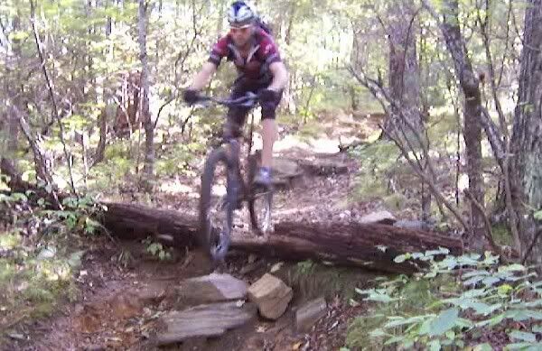
Once at the top we headed past the shelter and on to Club Gap. Normal incredible Pisgah riding in that section of trail. Steep ups, steep downs, danger around every corner. Here’s a grainy vid-cap of Josh rolling off the notchlog:
At Club Gap is the intersection of Avery Creek trail. We headed down Avery which is one of the sickest, steepest, rockiest, fun fun fun runs in this section of the forest. It’s not Farlow nasty, but it feels pretty remote and there was little evidence that anyone had been back there in quite some time. I led for the majority of the descent and missed Josh’s impact with a tree. The pace slowed *a little* after that but we were all still flying down the trail. Avery starts to run next to it’s namesake after the steep stuff and there’s even a little climb at the end back up to the road. We were back in camp right around noon so we must have knocked it out in about two hours. Not bad, all things considered. A large group was heading out right as we returned and I didn’t get to say ‘goodbye’ and ‘thanks’ to everyone for coming out and entertaining me this weekend. I had a great time. I’ll see a bunch of you at the DOUBLE DARE in a few weeks!